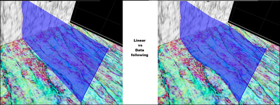
Adaptive Fault Interpretation with data following fault surfaces
With the introduction of data following surfaces, users of GeoTeric 2017.2.1 can now accurately track faults that truly follow their data in just a few clicks.
The patent pending approach allows the fault surface to snap to any data - whether this is a single fault attribute, reflectivity or a color blend.
 |
GeoTeric 2017.2.1 also contains the following:
- We have done a lot of work on improving the responsiveness of GeoTeric when adding and removing items to the 3D scene and when interacting with slices and Arbitrary Lines in the 3D scene.
- The complete line feature for Adaptive Horizons was not working as expected in 2017.2, meaning users had to track on slice before it worked - this has been fixed.
- Changing source volume on slices displayed in the interpretation window sometimes didn’t update the data correctly - resolved.
- The well correlation panel sometimes crashed when adding seismic track to the view - this has been fixed.
- Sometimes if user moved off GeoTeric with the cursor, it would get stuck in fault tracking mode and you were unable to end the fault picking.
- Very rarely, the 3D scene would become visually corrupted when tracking data following sticks - this has been fixed.
- Exporting a SEG-Y to floating point now automatically defaults scale to none.
- Noise Expression: When the temp directory is stored on a network drive, the performance is now equal to that of when it’s local.

