

The use of geologic expression workflows for basin scale reconnaissance: A case study from the Exmouth Subbasin, North Carnarvon Basin, northwestern Australia
by: N. McArdle (ffA), D.Iacopini (University of Aberdeen), M. KunleDare (ffA) and G.Paton (ffA)
The focus of this study is to demonstrate how seismic attributes can be used in the interpretation workflow to
rapidly obtain a high-resolution view of the geology that is imaged within a seismic data set.
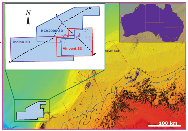 |
| Basemap showing location of Indian, Vincent and HCA200A 3D surveys of the Exmouth subbasin, northwestern Australia |
To demonstrate the
efficacy of seismic attribute analysis to basin scale reconnaissance, we apply a workflow to seismic data sets from
the Exmouth Subbasin, northwestern Australia, with the aim of determining the geologic expression of the subsurface.
Of specific interest are Barrow Group Jurassic and Cretaceous fluvial and marine sediments, that were
faulted during the Jurassic-Cretaceous rifting associated with the breakup of East Gondwana.
Regional-scale interpretations
are made to develop a tectonostratigraphic context to the investigation. Target-level analyses, focused
on features of exploration interest identified using regional reconnaissance, are made to calibrate attribute
response and demonstrate the effectiveness of seismic attributes for rapid evaluation of prospectivity in the initial
stages of exploration.
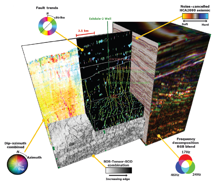
The main structural episodes are distinguished using dip and azimuth attributes, and faulting
is expressed using a combination of edge attributes which are used to create fault trend lineations. We observe
three main structural trends: the main northeast–southwest Jurassic-Cretaceous syn-rift primary fault orientation
of 48°, a secondary trend of 108°, taken to represent secondary conjugate faulting and a third trend of 100° interpreted
as the reactivation of these faults into the postrift sediments.
Stratigraphic attributes that respond to
amplitude and frequency are used to create reservoir scale geobodies of faulted Macedon turbidites, which in turn
are used for detailed tuning sensitivity analysis.
The final part of the investigation is of the syn-riftmagmatic system
responsible for sills and dikes that exploit the normal fault network. These intrusive and extrusive features are important as are potential drilling hazards and can act as baffles to hydrocarbon migration.
 |
|||
|
