One common question for GeoTeric users is how best to scale amplitude data for optimal visualisation and analysis. In this article, we present some useful definitions and tips for ensuring the best experience when interpreting seismic data in GeoTeric.
1. GeoTeric Data Types
GeoTeric only supports integer values for volume data, meaning that each amplitude within a seismic cube being displayed must be a whole number. To facilitate this, GeoTeric volume formats support 8, 16 and 32 bits, such that the following dynamic ranges are possible:
|
Bit depth
|
Maximum Dynamic range
|
|
Unsigned 8-bit
|
0-255
|
|
Signed 16-bit
|
-32768 to +32767
|
|
Signed 32-bit
|
-2147483648 to 2147483647
|
This means that for example, a 16-bit seismic cube can contain approximately 65,000 different discrete amplitude values. In this notation, n-bit means 2n values, so 16-bit is equivalent to 216 degrees of freedom.
You can see what amplitudes are present in the interval of interest by looking at the cursor reporting in GeoTeric scenes, the Opacity Editor, and the colour bar compression metrics.
2. Colour Bars and Visualisation
While most modern GPUs are capable of displaying 24-bit colour depth (8-bits per channel in red, green and blue), it can be extremely resource intensive and impractical to render seismic data or attributes in this manner. LCD monitors are also not always good at displaying 24-bit true colour. For this reason, different visual scaling and interpolation methods are used to balance quality of display with computer resource consumption.
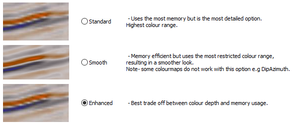
The choice of interpolation method can also have an influence, as selected in Options > Volume Interpolation. Standard interpolation utilizes full 24-bit rendering, at the expense of memory, however Enhanced and Smooth interpolation render at 12-bit.
In GeoTeric, there are two aspects in play: ensuring that the seismic amplitudes are scaled appropriately for the task in hand, and that the colour bar is interacting with those amplitudes suitably. The GeoTeric colour bars do not have fixed values: when displaying data, the colour map will be normalized and extrapolated across the range of values present, and the visual fidelity depends on the interpolation method used.
In general, GeoTeric will autofit colour maps across a range of 2n that is the smallest bracket around the detected amplitude range. So if a seismic cube has an amplitude range of approximately +/- 8000, GeoTeric will map the colour bar across a 14-bit range (16384 total values, or +/-8192).
A commonly encountered issue is in the visualization of very low amplitudes, relative to those elsewhere in the seismic cube. In these scenarios, the lowest amplitudes might look faint or indistinct as they represent a very small segment within the entire range, as in the below figure. Some solutions are presented below.
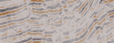 |
| These seismic amplitudes appear blocky and washed out where they are low, because they are occupying a relatively small portion of the colour map space. |
3. Scaling on Import
The most effective step is to ensure the data has been scaled appropriately when loaded into GeoTeric, especially if it originally comprised floating point values, e.g. a range of -1.476 to 1.928.
Search in the GeoTeric software help file for “Data Loading Tips” and “Load Floating Point Data” for tutorials on these topics.
4. Scaling within GeoTeric
Once data is loaded in GeoTeric however, the amplitudes of interest might still be very low and difficult to see. This can be because there is a strong contrast between high and low amplitudes, peculiarities of gain correction, or low impedance variation. In this case rescaling can be applied within GeoTeric. Note however that if amplitudes have been compressed during the loading process, and information has been lost, the data might need to be reloaded with attention paid to the preservation of those amplitudes.
Please search the GeoTeric help file for “Data Scaling”, “Convert”, and “Parser” for more information on carrying this out.
5. Specialist Scaling
In some cases, tricks using the GeoTeric colour map compression can be used to help with low amplitudes. If a 16-bit volume has high amplitudes in redundant parts of the data, for example on the seafloor reflection, but low amplitudes in the reservoir section, it can be clipped to take advantage of the colour map compression. The Parser tool is used to achieve this.
In this example, the amplitudes above and below 4000 are clipped such that the data fits within a 12-bit (+/- 4096) dynamic range, and will then make better use of the full range of the colour map. The amplitudes in the interval of interest remain unchanged.
|
Volume type
|
16-bit
|
|
Highest amplitudes
|
+/- ~30,000
|
|
Amplitudes of interest
|
+/- ~3000
|
|
Parser expression
|
((im1>=4000)*4000) + ((im1<=-4000)*-4000) + (((im1<4000)&(im1>-4000))*im1)
|
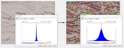 |
| The amplitudes of interest in this data now occupy the full useful extent of the colour bar, and are readily visible without further colour bar compression. |
Non-linear scaling can also be applied where there are very extreme amplitude contrasts, although this should not be applied in cases where amplitude preservation is sensitive. In this example a square root function has been applied to the amplitudes, such that the low values are boosted, and the high values suppressed. Note that the power law function in the GeoTeric Parser retains the correct sign, to preserve polarity in volume calculations.
|
Volume type
|
32-bit
|
|
Parser expression
|
(im1^0.5)*(2147483648^0.5)
|
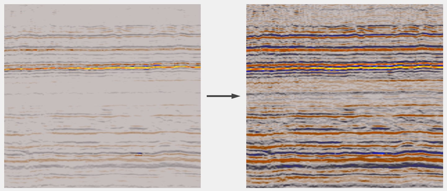 |
| In this example, the highest amplitude reflector is preserved, while the background signal which was previously too weak to see has been restored. |
For further Parser examples and explanations of the terms, expressions and syntax applied, search for topics containing “Parser” in the help.
For help and more information on any of these topics, feel free to contact your local GeoTeric office, or email support@geoteric.com.

