

Geoteric’s Adaptive Horizons tool allows the user to intuitively and interactively edit a tracked surface or interpretation. This is done by identifying the mis-pick in the interpretation, selecting the “3D edit” icon, and re-interpreting the line (we recommend using Piecewise Tracking).
This will then update the tracked surface in the surrounding area. The tick-box enables “3D Edit Override”, so any interpreted lines will be removed or overwritten. This is useful when the interpreted lines have been incorrectly positioned by the user.
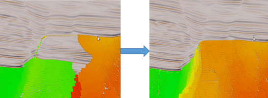
| With 3D edit selected, interpret the correct position |
The surface in the vicinity automatically updates |
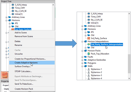
A horizon surface that has been imported from a third party software can also be converted into an Adaptive Horizon and edited in 3D. This allows the user to effectively resolve mis-picks in any horizon. This can be done by right clicking on the horizon and then selecting “Create Adaptive Horizon”. The reformatted horizon will appear in the Horizon Interpretations folder.
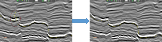
When doing any 3D editing, it is recommended to make sure the display is set to “View All”, this allows the interpreter to actively see the 3D repositioning of the surface surrounding the re-interpreted line. However, the user is free to switch to “View Active Intersection Only” if the user wishes to only view the overlay of the horizon interpretation (as shown below). This is effective if the view of the surface is blocking the line upon which the user is interpreting.
It is also recommended to do the 3D editing on an area that has some good interpretation surrounding it, this allows the surface to latch on to the interpreted areas more effectively. The 3D editing is most often needed (and effective) when interpreting reflectors in complex, faulted areas.
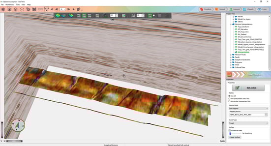
3D editing can also be useful for tracking your horizon interpretation without needing to fill it in the base map, allowing the interpreter to “fill as you interpret”. This means that the surface can be built up and QC’d rapidly while the interpretation is underway. In the example below, a High Definition Frequency Decomposition RGB Blend is data mapped, aiding the interpreter to identify potential mis-picks, as the lines are being interpreted.
The “3D edit” option will always fill the surface using the Graph Theory algorithm. This means a solid surface will always be created even if the initial tracked surface being edited had holes in it.
